
|
Follow us on |
Latest News Garmin Marine Charts and Maps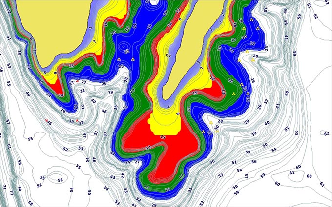 Tuesday, October 08, 2019 Garmin BlueChart® g3 coastal charts and LakeVü g3 inland maps provide superior coverage, clarity and detail with integrated Garmin and Navionics® content and Auto Guidance1 technology. AUTO GUIDANCE TECHNOLOGY Auto Guidance1 technology uses your desired depth and overhead clearance to calculate routes and show a suggested path to follow — overlaid onto your chart. AMAZING DETAIL BlueChart g3 coastal charts and LakeVü g3 inland maps possess the best of Garmin with the best of Navionics data, bringing you advanced chart detail for navigation as well as up to 1’ contours for improved fishing. UPGRADE TO PREMIUM Want even more from your charts and maps? Then step up to BlueChart® g3 Vision and LakeVü g3 Ultra. HIGH-RESOLUTION RELIEF SHADING The High-resolution Relief Shading feature is available on both BlueChart g3 Vision charts and LakeVü g3 Ultra maps. It combines color and shadows to give you an easy-to-interpret, clearer view of bottom structure at a glance and provides more detail than contour lines alone. HIGH-RESOLUTION SATELLITE IMAGERY High-resolution satellite imagery is available on both BlueChart g3 Vision charts and LakeVü g3 Ultra maps. Overlaid onto navigational charts, it provides a realistic view of your surroundings and helps enhance your situational awareness. CHOOSE WHICH ONE IS RIGHT FOR YOU
National Sponsors                             |
||
| © 2003 - 2026 U.S.A. BASSIN All rights reserved. | ||


 CMS.
CMS.